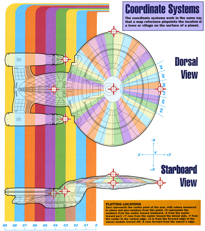
Coordinate Systems
Navigating a starship requires an enormous amount of data to help pinpoint the vessel's position.
 The USS Enterprise NCC-1701-D employed a series of external and
internal coordinates to ensure that any point on the ship be located easily and accurately, even by personnel
who were unfamiliar with the vessel.
The USS Enterprise NCC-1701-D employed a series of external and
internal coordinates to ensure that any point on the ship be located easily and accurately, even by personnel
who were unfamiliar with the vessel.
The internal and external coordinates were based on a three-dimensional mathematical system of three axes, in
which the X axis ran horizontally from port to starboard across the ship, the Y axis ran vertically from dorsal
to ventral, and the Z axis ran horizontally from fore to aft. In the case of the Enterprise, the accuracy of
this system was improved even further as the coordinates were calculated specifically for each of its
configurations, i.e. there was one set of coordinates for when the two sections of the ship were combined (called
'docked configuration'), and separate ones for the saucer module and the battle section when these components
were separated. The set of coordinates being used was identified by a subtext letter; the docked configuration
was identified by a 'D', (XYZD), the saucer module by an 'S' (XYZS), and the battle
section by a 'B' (XYZB). Other major areas of the ship were also given their own specific
coordinates, such as the warp nacelles, which were designated by XYZNP for the port nacelle and
XYZNS for the starboard nacelle.
The distance from each point of origin was measured in centimeters. Thus, a point located on the saucer module
hull that was 489 centimeters toward starboard, 1,034 centimeters toward the dorsal plane, and 1,296 centimeters
toward the aft edge from the point of origin was represented by the coordinate XYZS 0489, 1034, 1296;
the subscript 'S' told the user that this point was calculated from the saucer module, rather than the docked,
coordinates. Inside the ship, an even more accurate series of coordinates came into use, based on a 15-digit
code. In addition to the XYZ coordinates, two other sets of numbers were also employed. The coordinate started
with a two digit number, which was the deck number; all coordinates for locations on that deck started with the
same digits. The next two digits gave the 'sector' number; the saucer module was cut into 10-degree sections,
making a total of 36 sectors.
In the engineering hull, the ship was divided into 10 sectors, which dissected the ship from fore to aft; zero
was the foremost sector, nine was at the aft of the ship. To avoid confusion with the saucer module sectors,
the digit '5' was always placed in front of the sector number of the engineering section. In this way, the
sectors of the engineering section were designated 50 to 59. After the two digits representing the sector
number, there were two digits for the compartment or station number within the sector. The final nine digits
were the XYZ coordinates within the compartment. Thus, a figure of 12-2306-234,426,187 represented a location
234cm toward port, 426cm toward dorsal, and 187cm toward aft in compartment six of sector 23, deck 12. Using
this system, a Starfleet officer was able to locate any point on the ship from the coordinate number alone,
even if they had never before visited the ship.
|
|
"U.S.S. ENTERPRISE NCC-1701-D" - SEPTEMBER 1999 ISSUE 5 STAR TREK: THE MAGAZINE COPYRIGHT OF PARAMOUNT PICTURES.
|